Castabala — the forgotten city of Cilicia and the sanctuary of the goddess Perasia
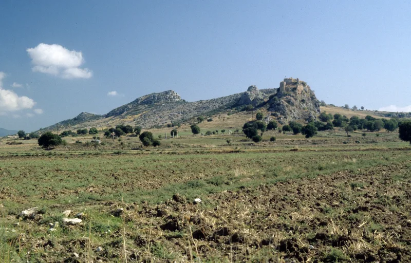
Castabala (Kastabala) is an ancient city located in the province of Osmaniye in southeastern Turkey, at the foot of a limestone ridge and in the floodplain of the Ceyhan River. Castabala was once one of the main spiritual centers of Hellenistic Cilicia, known for its ecstatic cult of the goddess Artemis Perasia. Today, it is a little-visited but surprisingly picturesque archaeological site featuring a colonnade of nearly two dozen surviving Roman columns, the ruins of Byzantine churches, and a fortress perched above the plain—a must-see for anyone exploring ancient Cilicia away from the bustling coastlines.
History and Origins
The earliest traces of settlement at the site of Castabala date back to the Luwian and Neo-Hittite periods—as evidenced by hieroglyphic inscriptions and basalt reliefs from the 9th–8th centuries BCE found in the surrounding area. The Greek name “Hierapolis Castabala” (“the sacred city of Castabala”) indicates its status as a major temple center long before the arrival of the Romans. The main cult was the worship of the goddess Perasia, a local form of Artemis or Cybele; according to Strabo, the priestesses of this goddess walked barefoot over hot coals without suffering burns.
In the 4th century BCE, Castabala came under the influence of the Seleucid Empire, and during the Hellenistic period, it became the capital of a small kingdom that minted its own coins. From 64 BCE, the city was incorporated into the Roman province of Cilicia and experienced a period of prosperity: paved streets, thermal baths, temples, and colonnaded porticoes appeared. During the Byzantine era, Castabala became a bishopric; the ruins of two early Christian basilicas with rich stone carvings have been preserved here.
The city’s prosperity was cut short by the Arab-Byzantine conflict of the 7th–8th centuries, after which Castabala gradually fell into ruin. In the Middle Ages, a Cilician-Armenian fortification was built on the cliff above the city—a typical example of the defensive architecture of the so-called “Lesser Armenian Kingdom.” After the 14th century, the city fell into complete ruin, and its stones were used by the local population to build houses and agricultural structures.
Archaeological Research
Systematic excavations in Kastaba began in the 1960s under the direction of Mahmut Gökhan Bey and continued intermittently until the 2000s. British, German, and Turkish scholars jointly mapped the colonnaded street, cleared the basilicas, and drew up a plan of the upper fortress. The artifacts found—terracotta figurines, coins, and mosaic fragments—are on display at the Adana Archaeological Museum (Adana Arkeoloji Müzesi). Of particular significance are the bilingual inscriptions in Greek and Aramaic, reflecting the borderland nature of Kastabala’s culture.
In the 2010s, the Turkish Ministry of Culture and Tourism included Kastabala on the list of candidates for the status of “Archaeological Park of National Importance,” which provided basic funding for the conservation of the columns and the path leading to the fortress. Nevertheless, tourism remains modest, making Kastabala one of the few places where you can stroll through a Roman city almost in solitude.
Architecture and What to See
The Castabala Archaeological Park is open 24 hours a day and is essentially free—thanks to this, it has the atmosphere of a “lost city,” something so rare in mass-tourism Turkey. The ruins stretch along a dusty country road, and it takes about two hours to see everything.
The Colonnaded Street
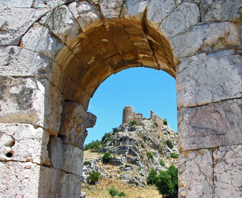
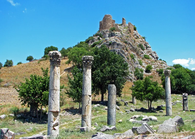
The most photogenic part of Kastabala is the main street with a colonnade of 17 surviving Corinthian columns. This street, about 300 meters long, was built in the 2nd–3rd centuries CE and served as the city’s main entrance. Shops and public buildings lined it. The stone capitals feature characteristic acanthus leaves and traces of reuse during the Byzantine era. The columns are made of local limestone, which has darkened over time and taken on a warm honey hue; unlike the marble colonnades of major Aegean cities, the Kastabali colonnade exudes provincial charm and authenticity. Some columns still retain the mountings for bronze statues of Roman emperors and local benefactors of the city.
Rock Fortress
On a sheer limestone cliff about 100 meters high stands a fortress, rebuilt by Cilician Armenians in the 12th–13th centuries on the foundations of earlier Roman-Byzantine fortifications. A trail leads to it from the southern slope, taking 25–35 minutes to climb. From the summit, a panoramic view opens up over the Çukurova Plain and the Amanus Mountains (Amanus, Nur Dağları). Inside the fortress, one can see cisterns for collecting rainwater, the remains of a chapel with fragments of frescoes, the arcade of a covered passageway, and fragments of fortress towers. The walls are constructed using the rusticated bossage technique characteristic of Armenian masonry—with a rough exterior texture and tightly fitted stones.
Early Christian Basilicas
In the lower town, the ruins of two Byzantine churches from the 5th–6th centuries have been preserved. The northern basilica had a three-aisled layout with an apse, mosaic floors (fragments preserved in situ), and a narthex. Archaeologists have documented inscriptions here mentioning the bishops of Kastabala, confirming the city’s status as a Christian center.
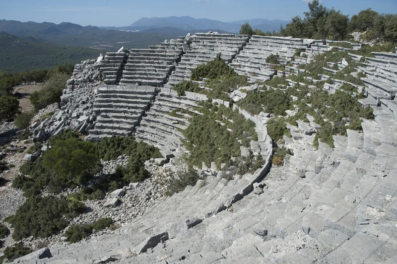
The Theater and Roman Baths
The modestly sized theater of Castabala could seat about 2,000 spectators and was built into a natural slope. Today, several rows of seats and a fragment of the stage are visible. Nearby lie the unexcavated ruins of Roman baths with a hypocaust system and marble baths; this complex has yet to be fully explored.
Necropolis
Beyond the city walls lies a necropolis with sarcophagi and stone tombs from the Roman and Byzantine eras. Some of the sarcophagi are decorated with reliefs featuring garlands, bull skulls, and epitaphs in Greek. Some tombs are typical of the region’s “houses of the dead”—gabled stone structures imitating residential buildings. Among the tomb inscriptions are references to teachers of rhetoric, city magistrates, and Christian presbyters—this cross-section of epigraphy provides valuable insight into the social structure of a provincial city in late antiquity.
Natural surroundings
The archaeological park is located in the picturesque valley of the Ceyhan River, surrounded by rolling hills with pomegranate, olive, and mulberry groves. In the spring, the fields around the ruins are covered with poppies and fragrant lavender thyme. Rare species of owls nest in the pine groves, and rock swallows and golden eagles can be found on the cliffs surrounding the fortress. This makes a visit to Kastabala appealing to nature lovers as well—here, you can combine archaeology with photography and a picnic in the shade of ancient poplars.
Interesting Facts and Legends
- According to Strabo (Geography, XII.2.7), the priestesses of Artemis-Perasia in Castabala walked barefoot over hot coals without getting burned—this ritual became the prototype for many ecstatic cults in the Eastern Mediterranean.
- Hellenistic coins from Castabala depicted the goddess wearing a tower-crown (a symbol of the city’s protection) and featured a rare combination of Greek and Aramaic inscriptions—evidence of the region’s cultural syncretism.
- During the Byzantine era, Castabala became a place of exile for several disgraced church figures, including a Nestorian bishop mentioned in the sources.
- The Armenian fortress above the city is mentioned in the chronicles of Leo II as one of the outposts on the eastern border of the Kingdom of Cilicia.
- For centuries, locals called the ruins “Bodrum Kale”—“underground fortress”—believing that Seleucid treasures were hidden beneath the colonnade; this legend attracted treasure hunters right up until the 20th century.
- In the 1990s, while clearing the colonnaded street, archaeologists discovered a reused slab with a bilingual Phoenician-Luwian inscription, which pushed the history of the settlement back to at least the 8th century BCE.
- In one of the Byzantine tombs at Kastabala, a bronze ring bearing a Christogram and an Aramaic inscription was found—a rare testament to the multicultural identity of the city’s inhabitants in the 6th century.
- In the lower city, archaeologists have documented traces of medieval agricultural activity—olive oil presses and stone millstones carved into ancient structures.
- Local legends link the name Bahçe (“garden”) to the “gardens of Perasia”—according to tradition, the surrounding gardens were planted by priestesses for the temple’s needs and fed generations of pilgrims.
How to get there
The Kastabalı Archaeological Park is located about 12 kilometers north of the city of Osmaniye, near the village of Bahçe-Kesmeburun. The most convenient way is by car: from Adana, take Highway O-52/D400 east for about 90 kilometers (1 hour 15 minutes), then turn north onto a local road; from Gaziantep, the drive takes about 2 hours. Signs for “Hierapolis-Kastabala Antik Kenti” appear about 5 kilometers before the site.
Without a car, you can take an intercity bus to the Osmaniye bus station, and from there, take a taxi (about 20–25 minutes) or a local minibus from the Bahçe district. There is no public transportation directly to the ruins, so it is more convenient to arrange the return trip with the driver in advance. The nearest airport is in Adana (Adana Şakirpaşa), about an hour’s drive away; you can also fly into Hatay (Hatay Havalimanı) and drive to Kastabalı in an hour and a half through the Aman Mountains valley. For those who prefer slow travel, the overnight train from Istanbul to Adana with a transfer to local buses is a good option.
Travel Tips
The best time to visit Kastabala is March–May and October–November, when the green Çukurova plain contrasts with the gray limestone of the ruins, and the temperature is comfortable for the climb to the fortress. Summers here are hot and dry, with temperatures often exceeding 35°C; without shade or infrastructure, the stay becomes difficult. In winter, short but intense rains are possible, washing out the dirt roads.
Bring water (at least 1.5 liters per person), comfortable shoes with sturdy soles—the terrain is rocky and uneven—and a hat. There are no restrooms, cafes, or souvenir shops on site, so it’s best to plan your lunch in Osmaniye. It’s helpful to download an offline map of the park: there are almost no signs inside, and you’ll have to find many sites on your own.
It’s a good idea to combine a visit to Kastabala with other lesser-known sites in the region: Toprakkale Castle, 25 kilometers to the west; the Armenian fortress of Yılankale; and the Karatepe-Aslantaş Archaeological Park with its Hittite reliefs. For hiking enthusiasts, the climb to the rock fortress is worth the effort—it takes about 30 minutes and rewards you with a magnificent panorama.
If you plan to explore ancient Cilicia in depth, set aside two or three days for the region: the first day—Castabala and Karatepe; the second—the Adana Archaeological Museum and Mopsuestia; the third—Issus (Alexander the Great’s battlefield) and the Hittite reliefs at Caferhöyük. Be sure to try the local specialties along the way—Adana kebab, kömbe, and sweet pomegranate juice. There are no hotels directly at the ruins; it’s better to stay in Osmaniye or Adana, where there is a wider selection of hotels and prices are reasonable.
Photographers are drawn to a special “golden hour” in Kastabala: early in the morning, the columns are bathed in warm amber light, and in the evening, the rock with the fortress casts a long shadow across the valley. Drone photography requires official permission from the Ministry of Culture—without it, the use of drones in the archaeological site is prohibited. If you are interested in the forgotten pages of Asia Minor’s history, Castabala, with its colonnade and fortress, is one of the most atmospheric places in Eastern Turkey.