Manjynik: A Hellenistic Watchtower Over the Şeytanderesi Canyon
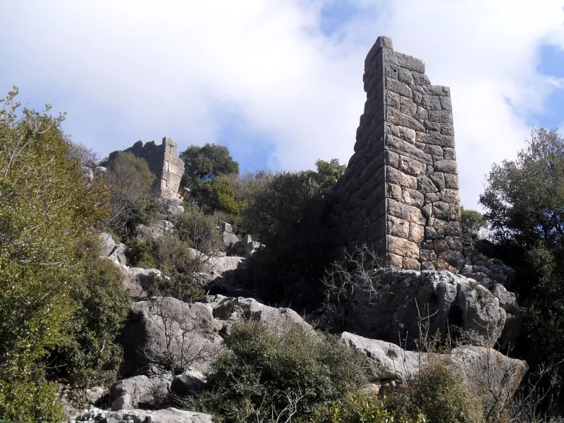
Perched on a cliff above the Şeytanderesi Canyon (“Devil’s Creek”), about ten kilometers from the Mediterranean coast, lie the ruins of the little-known but architecturally striking Mancınık Kalesi fortress. The polygonal masonry of its walls bears the hallmark of Hellenistic craftsmen, and the preserved Greek word “οἰκοδόμος” (builder) on one of the slabs unequivocally confirms its dating. This is a rare example of a mountain fortress from the late 3rd–2nd centuries BCE that has survived to the present day without major later alterations.
History of the Fortress
Mancınık was built during the Hellenistic era—likely in the 2nd–1st centuries BCE—during the struggle for Cilicia between the Seleucids, the Ptolemies, and local dynasts. The fortress controlled one of the mountain trails connecting the coast near Silifke with the inner Taurus Plateau.
The first systematic archaeological survey of the site was conducted in 1987 by the Turkish archaeologist Levent Zoroglu. He documented the layout, the remains of several inscriptions, and the nature of the masonry. Most of the inscriptions are heavily eroded, but the Greek word “οἰκοδόμος” that was deciphered confirmed the Hellenistic origin and Greek cultural affiliation of the builders.
There is little reliable information about the fortress’s later inhabitants. It is indirectly assumed that the fortification was also used during the Byzantine era, like most of the mountain forts of Isauria, but no major reconstructions, visible in the masonry, have been identified. The Turkish name “Mancınık” means “catapult, trebuchet”—it was given by popular memory as early as the Middle Ages, when the fortress’s origins had been lost.
Architecture and What to See
Polygonal masonry
The main architectural feature of Mancınık is its walls, built from large polygonal (multi-sided) blocks without mortar. This technique is characteristic of Hellenistic fortifications in the Mediterranean: the blocks are carefully fitted together to form masonry resistant to earthquakes and undermining. The preserved sections reach several meters in height.
Towers and Gates
The remains of several towers and one main entrance are visible within the fortress. The exact proportions have been reconstructed only partially—the walls have crumbled significantly, and a large portion of the masonry lies in the debris at the foot of the cliff.
Inscriptions
The Greek word “οἰκοδόμος” (“builder”) has been preserved on one of the slabs. Several other inscriptions are so damaged that they cannot yet be read. This is a typical situation for mountain fortresses in the region: epigraphy suffers first and foremost.
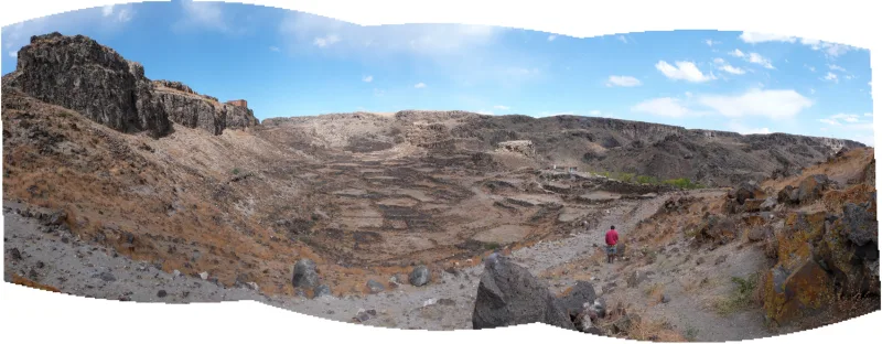
Views of the Canyon The fortress stands on a cliff overlooking the Şeytanderesi Canyon. From the upper sections of the walls, a wide panorama of the gorge and the slopes of the Taurus Mountains opens up—the location was not chosen by chance: the entire trail was visible from the cliff.Interesting facts
- The Turkish name “Mancınık” (“catapult”) is a later folk name. The ancient name of the fortress has not yet been established.
- The dry-stone masonry preserved at Mancınık is considered one of the prime examples of Hellenistic fortification techniques in Cilicia.
- The Şeytanderesi Canyon (“Devil’s Creek”) is an impressive natural site in its own right, with nearly vertical walls and endemic flora.
- Mancınık is virtually untouched by tourists: it is absent from most guidebooks on Mersin, making it a destination for dedicated local historians.
- The Greek word “οἰκοδόμος” on one of the slabs is effectively the builder’s “signature,” a rarity for ancient fortresses.
How to get there
The fortress is located in the Silifke district of Mersin Province, at coordinates 36°31′ N, 34°03′ E, approximately 10 km from the Mediterranean coast. From the D400 highway, turn toward the inland villages and continue along a dirt road toward the Şeytanderesi Canyon.
Base camp: Silifke (about 20–25 km). It is difficult to get there without a rental car: there is no public transportation directly to the fortress. From the nearest village to the ruins, there is a steep hike up a rocky trail that requires caution. It is advisable to bring a GPS and a pre-downloaded offline map.
Tips for travelers
The best time to visit is March–May and October. In summer, the rock and trail get very hot, and there is practically no shade. In winter, rain is possible, and the canyon may temporarily flood.
Sturdy hiking boots, at least 1.5 liters of water per person, and a hat are mandatory. If you’re going without a guide, let someone know your route: cell service in the canyon is unreliable.
Do not touch the masonry or attempt to lift fallen stone fragments: even a gentle nudge of a polygonal stone can destabilize neighboring ones. Respect the inscriptions—they are fragile and wear away quickly when touched.
Mancınık is conveniently combined with a visit to Silifke Castle and the Cennet ve Cehennem Caves—all three sites are located within a 25–30 km radius. For those who want to see a rare Hellenistic fort untouched by tourists, a trip to Mancınık will be a real discovery.