The White Bridge: A Roman Crossing over the Granicus
In northwestern Turkey, near modern-day Biga in the province of Çanakkale, the Granicus River (Turkish: Biga Çayı) was once spanned by Akköprü—the “White Bridge.” In the Late Roman period, it was one of the largest bridge structures in Mysia: eight arches, marble retaining walls, and masonry made of brick and small stones. Only fragments of the bridge have survived to the present day: in the 19th century, it was largely dismantled for building materials for local roads. But even the remains and old descriptions leave an impressive picture of the engineering thought of late Antiquity.
History of the Bridge
The White Bridge across the Granicus was built, according to researchers, in the 4th century CE—likely during the reign of Emperor Constantine the Great (died 337 CE). This was an era of active restoration of Roman roads in Asia Minor and the strengthening of communications between Constantinople and the Asian provinces. The bridge provided a crossing over the capricious Granicus River, known since the time of Alexander’s battle with the Persians in 334 BCE.
The first detailed description of the bridge was provided by the English traveler Edmund Chishull in 1699: at that time, the structure was still largely intact. In the 19th century, it was inspected by William Turner (1815), Pyotr Chikhachyov (1847), and in the 1890s by the German explorer Janke. All of them noted characteristic Roman features: load-bearing chambers beneath the roadway, marble cladding, and brick-and-stone masonry.
The bridge’s downfall came in the 19th century: stone and marble were actively stripped away for the construction of local roads and buildings. By the early 20th century, when British archaeologist Frederick W. Hasluck surveyed the area, only scattered fragments remained of Akköprü. Today, only isolated foundations and pieces of masonry remain in the riverbed and along the banks of the Biga.
Architecture and What to See
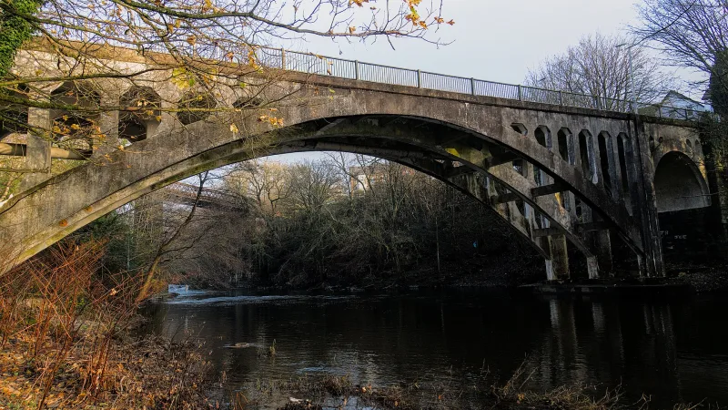
Eight Arches
The bridge in its entirety had eight arches: four main ones spanning the main river channel, and four smaller ones—flood arches—on the sides. The longest span was about 18 paces (approximately 13–14 meters), and the width of the roadway was about 8 paces (about 6 meters).
Materials
The bridge was constructed of brick and small rubble stone with marble retaining walls on the sides. This combination, characteristic of late Roman Late Antiquity, ensured both strength and an elegant appearance: the marble facades reflected light, while the brick core absorbed temperature fluctuations.
Unloading chambers
Underneath the roadway were unloading chambers—hollows that reduced the weight of the structure on the supports. This technique is typical of the Roman and early Byzantine bridge-building schools and is well documented in 19th-century descriptions.
What Remains Today
Today, only scattered fragments of the bridge remain: the bases of the supports in the Biga Riverbed, fragments of brickwork, and scattered marble blocks. There is no full-scale “tour” as such—this is a site for local historians and those interested in Roman engineering.
Interesting facts
- The bridge stood on the Granicus River—the very same river on whose banks Alexander the Great won his first major victory over the Persians in 334 BCE.
- The bridge was best documented by Edmund Chishull in 1699—an English traveler and chaplain who traveled through Asia Minor.
- The bridge’s systematic destruction was not caused by wars or earthquakes, but by economic “cannibalism”: in the 19th century, its marble and bricks were used for local roads.
- Akköprü (“White Bridge”) is the popular Ottoman name, derived from the whiteness of the marble cladding: from a distance, the bridge did indeed look bright.
- Today, the site is rarely included in tourist itineraries—it is a rare “forgotten” ruin of the Roman Mission.
How to get there
The remains of the bridge are located near the modern town of Biga in the province of Çanakkale (northwestern Turkey, Marmara region). Coordinates: 40°22′21″ N, 27°18′36″ E. From Çanakkale to Biga—about 80 km. From Istanbul—about 250 km via the ferry crossing or the 1915 Çanakkale Köprüsü bridge.
It is best to drive to the ruins themselves: there is no public transportation directly to the site. A landmark is the modern bridge across the Biga River in the vicinity of Biga; the old piers are visible in the riverbed and on its banks.
Tips for travelers
Be prepared for the fact that there is no classic “tourist attraction” with a sign and a trail here. This is a destination for those who specifically travel to the region to see the Roman and Byzantine traces in Mysia. Bring along 19th-century descriptions and photographs—without them, it is difficult to imagine the bridge’s original scale.
The best time to visit is late spring and early fall: the water level in the Bigi is lower, and the foundations of the supports are more visible in the riverbed. In winter and spring, floods can completely submerge the fragments.
Combine your visit with a trip to Troy (Truva), Çanakkale, Assos, and Kızılcukur—this allows you to put together a substantial itinerary covering ancient Mysia and the Troad in 2–3 days. Bring sturdy shoes and insect repellent: the approaches to the river are often marshy and overgrown with reeds.
Respect the remaining ruins: do not attempt to move the stones or take any “souvenirs.” This bridge has already suffered more damage than many surviving Roman structures—every stone here is a rarity and a valuable resource for future research.