Sillium—a Pamphylian fortress on a plateau that Alexander could not conquer
Thirty-four kilometers from Antalya, overlooking the Pamphylian plain, stands one of the most impregnable cities of antiquity on a rocky plateau. Sillium is the city that withstood the onslaught of Alexander the Great in 333 BCE. Arrian, in his *Anabasis*, records the fact without elaboration: the fortifications were too strong, the garrison of hired soldiers and “barbarians” too large, and the conqueror, eager to press on, abandoned the siege after the first unsuccessful assault. Syllium survived—not because anyone defended it, but because no one could take it from below or bypass it from above. Today, the ruins on the plateau are exposed to the winds and tourists, though part of them slid away in the 1969 landslide—and that, too, is part of history.
History and Origin of Sillion
The city’s original Pamphylian name is Selywiys. It is recorded on early coins as ΣΕΛΥΙΙΥΣ, where the letter I represents the Pamphylian sound /w/. Researchers trace this name back to the Hittite Sallawassi—evidence that a settlement on the plateau existed even before Greek colonization. Stephen of Byzantium provides several spellings: Σύλειον, Σύλαιον, Σύλλον, Σίλονον. The Greek and Byzantine form Syllaion became established.
Tradition is divided regarding the city’s founding. One version speaks of colonists from Argos. Another places Syllion in the company of Side and Aspendos: all three, according to this version, were founded by the soothsayers Mopsus, Calchas, and Amphilochus after their return from Troy. Around 500 BCE, Pseudo-Scylax refers to it as a polis. From 469 BCE, Syllaion joined the Athenian League and is mentioned in lists of Athenian allies around 450 and 425 BCE.
In 333 BCE, when Alexander’s army marched north through Pamphylia, Sillium did not open its gates. Arrian writes: “The city itself was situated in a fortified position, and there stood a garrison of mercenaries and local barbarians”—Alexander, in a hurry to reach Gordium, abandoned the siege. After his death, Sillium came under the rule of the Seleucids, during whose reign a theater and part of the city’s infrastructure were rebuilt. When most of Western Asia Minor passed to the Attalids of Pergamon, Sillium retained its status as a “free city” by decision of the Roman Senate.
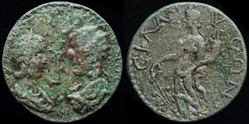
Sillium’s coinage tradition is one of the longest in Pamphylia: continuous minting from the early 3rd century BCE until the reign of Aurelian in the 270s CE. Silver tetradrachms of the Alexandrian and Lysimachian types were issued between 281 and 190 BCE; the rest of the coinage was in bronze.
During the Early Byzantine period, Sillion rose to prominence: in 677–678, an Arab fleet returning from an unsuccessful siege of Constantinople was lost in a storm near the city. The city became the residence of the imperial representative—the “ex prosopu”—and a stronghold of the maritime phyme of the Kyvirreotes. Between 787 and 815, the episcopal see was transferred there from Perga. In 1207, the city was captured by the Seljuks.
Architecture and What to See
The ruins of Sillion span the Hellenistic, Roman, Byzantine, and, in part, Seljuk periods. They are scattered across a rocky plateau above the village of Yanköy, at an elevation of about 200 meters above the plain. Part of the ruins no longer exists: in 1969, a massive landslide destroyed an entire section of the city. The remaining part is still at risk of landslides.
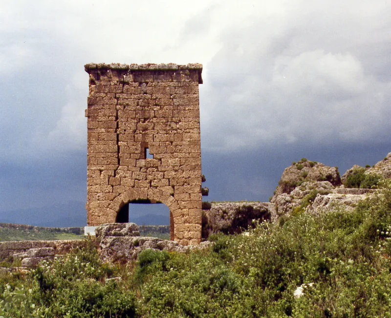
City Gates
The main city gates are fairly well-preserved and offer a glimpse of the monumental entrance architecture of the late Roman Sillium. The gates are flanked by towers and feature an arched structure characteristic of Pamphylia.
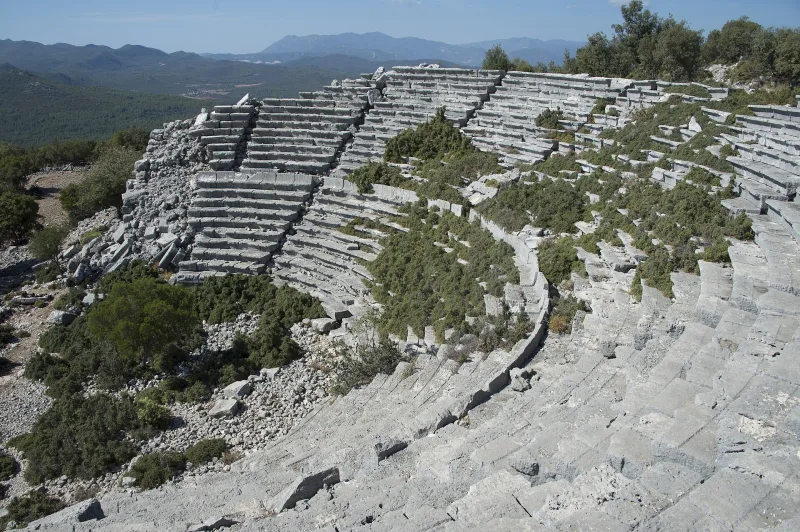
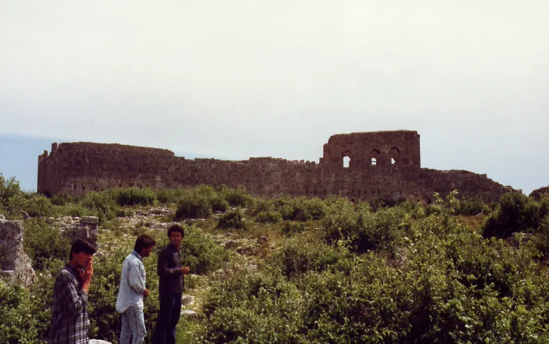
Stadium, Amphitheater, and Odeon
The outlines of the stadium can be discerned on the eastern part of the plateau. The amphitheater and odeon—two different types of entertainment venues—reflect the vibrancy of city life during the imperial period. Part of these structures was damaged by the 1969 landslide.
Temple and cistern
The remains of a temple have been preserved on the site—presumably dedicated to one of the Olympian gods (the exact identification has not been established). Nearby is a large cistern that supplied water to the plateau, which lacks a permanent water source. This is a typical engineering solution for Pamphylian rock-cut cities: without cisterns, life at this altitude would have been impossible.
Gymnasium and City Quarters
The remains of the gymnasium—a place for physical exercise and cultural life—are located in the central part of the plateau. Traces of city quarters can be discerned around it: ruins of houses, streets, and remnants of walls. The acropolis, with its surviving walls, frames the panorama from the north.
Interesting facts and legends
- When Alexander the Great retreated from the walls of Sillion in 333 BCE, it was one of the rare instances where a city-state survived precisely because of its topography, rather than diplomacy or wealth. Selge in the north took a different approach—it sent an embassy. Sillion remained silent and survived.
- In 677–678, an Arab fleet returning from Constantinople was destroyed by a storm near Sillion. This episode is part of a long series of unsuccessful Arab expeditions in the Aegean and Mediterranean Seas during the 7th century, which defined the border between the Islamic and Christian worlds for several centuries.
- The coinage of Sillion from the late 4th century BCE to the 270s CE constitutes an exceptionally rare continuous numismatic series. Early coins bear an inscription in the Pamphylian dialect of Greek, where the special letter I denoted the sound /w/—a sound lost in standard Greek.
- After 1969, when a landslide destroyed part of the ruins, it became clear that Sillion stands on unstable ground. It is a paradox: a city that no enemy could capture for millennia is slowly being destroyed by the forces of the mountain itself.
How to get there
Sillion is located 34 kilometers east of the center of Antalya, near the village of Yanköy. The nearest airport is Antalya (AYT). By car from Antalya: take Highway D400 eastward, through Belek and Serigi, then follow the sign for Yanköy. GPS: 36.9925° N, 30.9897° E. The drive takes about 45 minutes. Public transportation is unreliable; it is better to rent a car or take a taxi from Antalya.
From the village to the plateau, it’s a hike uphill. The site is not fenced off; admission is free. Combine your visit with Perge (25 km to the west) and Aspendos (45 km to the east)—together, they provide a complete picture of Pamphylian archaeology in a single day.
Tips for travelers
The best time to visit is spring and fall: in summer, the open plateau is hot and there is no shade. Bring water—there are no springs or food vendors at the top. Shoes with non-slip soles are a must: the slopes are rocky.
Some of the ruins are located near the edge of the plateau—stay away from the cliffs, especially if the ground is wet after rain. Do not get too close to cracks in the ground: the risk of landslides is real. Bring binoculars: from the walls, you can see the entire Pamphylian plain all the way to the sea—the panorama alone is worth the climb.
Don’t expect tourist infrastructure: there are no ticket offices, signs, or attendants here. This is a place for independent travelers ready to interpret the ruins without prompts. Sillion is the antithesis of Perge and Aspendos: not a restored, polished museum, but a living sense of time that cannot be paused.