Şirakavan: Bagratiidų armėnų sostinės griuvėsiai Akhuryan upės krante
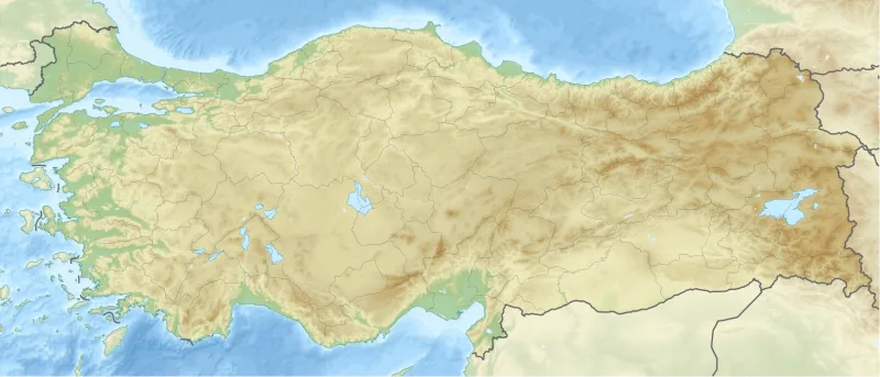
Dešiniame Akhuryan upės (turkų kalba – Arpaçay) krante, už kelių kilometrų nuo šiuolaikinės Armėnijos ir Turkijos sienos, yra Širakavano griuvėsiai – senovės armėnų miesto, kuris 890–929 m. buvo Bagratiidų karalystės sostine. Turkiškas vietovės pavadinimas – Yerazgavors; jis atitinka šiuolaikinį Çetindurak kaimą Akyaka rajone, Kars provincijoje. Šiandien iš miesto liko tik tvirtovės pamatai ir Surp Prkich (Šventojo Gelbėtojo) bažnyčios fragmentai, tačiau istorinė vietos reikšmė yra milžiniška: būtent čia 890 m. katalikas Gevorgas II karūnuoja karalių Smbatą I, pradėdamas armėnų valstybingumo aukso amžių.
Istorija
Gyvenvietė atsirado VII a. pavadinimu Yerazgavors; armėnų istorikas Sebeosas ją minėjo kaip „kaimą Širako kantone, Airarato provincijoje, Didžiojoje Armėnijoje“. IX a. karalius Smbatas I iš Bagratiidų dinastijos gyvenvietę pavertė dideliu miestu, o 890 m. čia perkėlė karalystės sostinę, vietovę pervadindamas į Širakavaną. Netrukus čia pat Smbatą karūnavo katalikosas Gevorgas II – šis įvykis armėnų kronikose užfiksuotas kaip lemiamas momentas atkuriant armėnų valstybingumą po ilgos arabų viešpatijos.
Şirakavan liko sostine iki 929 m., kai karalius Abas I perkėlė sostinę į Karsą (vėliau ten persikėlė ir valdžios centras, o po to – į žymiausią Ani). Tačiau miestas neprarado savo reikšmės: X–XI a. čia toliau vyko aktyvus miesto gyvenimas, veikė amatų dirbtuvės, monetų kalykla, turgūs.
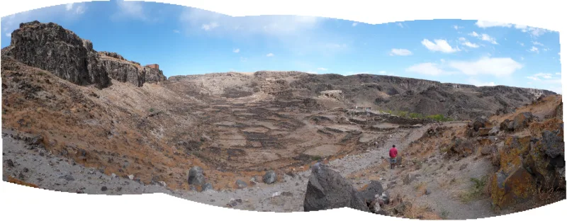
XI–XII a. Širakavanas turėjo centrinę tvirtovę, apsuptą galingų gynybinių sienų. 1064 m. miestą nugriovė seldžiukų sultono Alp Arslanas kariuomenė – ta pati kampanija, kuri baigėsi Ani užėmimu ir sunaikinimu. Vėliau Širakavaną iš dalies atstatė armėnų kunigaikščiai Zakarianai, tačiau buvusios reikšmės jis jau nebeatgavo. XX a. pradžioje tai buvo paprastas kaimas, kuriame gyveno apie 1220 žmonių; 1920 m. gyventojai išsikėlė, o 1954 m. Surp Prkich bažnyčia buvo iš dalies sunaikinta per Turkijos karines pratybas. Dėl užtvankos statybos buvo užtvindyta dalis likusių archeologinių zonų.
Architektūra ir ką pamatyti
Surp Prkich (Šventojo Gelbėtojo) bažnyčia
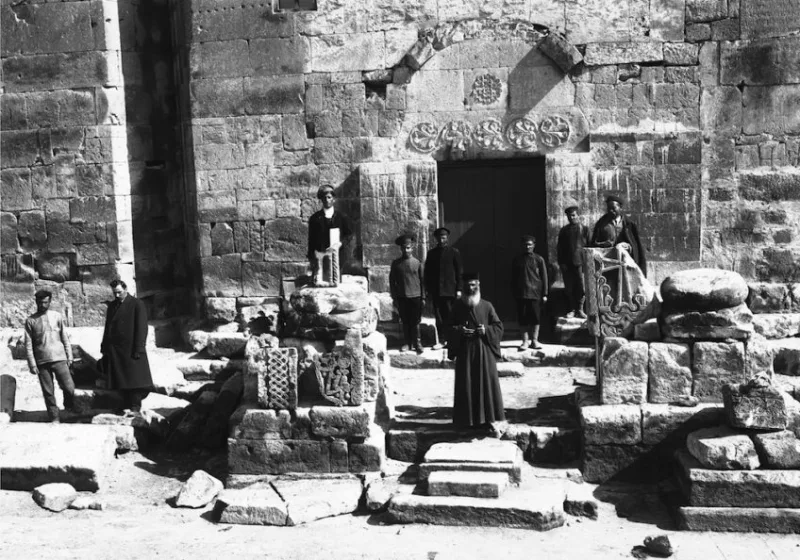
Pagrindinis Širakavano paminklas – Surp Prkich bažnyčia, pastatyta 880-aisiais metais. Tai buvo kryžminio kupolo statinys su centrine apsida, keturiais stulpais ir kupolu ant skliautų. Būtent čia 890 m. buvo karūnuotas Smbatas I. Iki 1954 m. išliko dalis sienų ir kupolo; po karinių pratybų ir vėlesnio sunaikinimo iš šventovės liko pamatų fragmentai ir apatinių sienų dalys. Išliko senos Toros Toramanyano 1908 m. nuotraukos, pagal kurias galima įsivaizduoti pirminį vaizdą.
Tvirtovė ir gynybinės sienos
XI–XII a. Širakavanas turėjo centrinę tvirtovę, apsuptą storų gynybinių sienų. Šiandien iš jų liko akmenų griuvėsiai, pagal kuriuos galima atsekti įtvirtinimų kontūrus. Tai tipiška armėnų karinei architektūrai sistema: citadelė centre, išorinės sienos perimetru, bokštai svarbiausiose vietose.
Gyvenamieji namai ir ūkio pastatai
Archeologiniai radiniai rodo tankią miesto užstatymą, būdingą IX–XI a. armėnų miestams: akmeninius namus, grindinius gatves, vandentiekį. Didžioji dalis šių radinių šiandien yra vos pastebima – beveik viskas užtvindyta arba paslėpta po žeme.
Kontekstas: pasienio zonos kraštovaizdis
Pati vieta yra reikšminga dėl savo išsidėstymo – dešiniame Akhuryan upės krante, kuria eina šiuolaikinė Turkijos ir Armėnijos siena. Iš griuvėsių teritorijos matoma priešinga Armėnijos pusė; giedromis dienomis – Aragats kalnas ir Echmiadzino siluetas tolumoje. Tai sukuria ypatingą nuotaiką: griuvėsiai žvelgia tiesiai į šiuolaikinę Armėniją.
Įdomūs faktai
- 890 m. Širakavane įvyko Smbato I karūnavimas – įvykis, atkūręs Armėnijos karalystę po šimtmečių arabų viešpatavimo. Šis aktas laikomas viena iš svarbiausių datų Armėnijos istorijoje.
- Širakavanas buvo sostine vos 39 metus (890–929), tačiau per tą laiką jis padėjo pagrindą Bagratidų laikotarpiui, kuris vėliau davė pradžią Ani – „tūkstančio ir vienos bažnyčios miestui“.
- Armėnų istorikas Toros Toramanyan 1908 m. padarė seriją Surp Prkich nuotraukų – tai pagrindinis vizualinis šaltinis apie bažnyčios architektūrą.
- Miestas buvo sunaikintas per tą pačią Alp Arslan seldžiukų kampaniją 1064 m., kaip ir žymiau žinomas Ani – du broliai miestai žuvo beveik vienu metu.
- 1954 m. Turkijos karinės pratybos sunaikino Surp Prkich bažnyčios likučius; vėliau dėl užtvankos statybos buvo užtvindyta dalis archeologinės zonos.
Kaip ten nuvykti
Şirakavan yra netoli Çetindurak kaimo Akyaka rajone, Kars provincijoje, dešiniame Akhuryan/Arpaçay upės krante. Nuo Kars miesto – apie 35 km į pietryčius, apie 45 minutes automobiliu. Artimiausias oro uostas – Kars Harakani (KSY), 30 km. Koordinatės: 40.7157°N, 43.7219°E.
Viešasis transportas į Çetindurak ribotas: retkarčiais važiuoja mikroautobusai iš Kars arba Akyaka. Patogiausia išsinuomoti automobilį arba iš Kars paimti taksi su grįžimu; susitarkite dėl laiko.
Atminkite: vieta yra pasienio zonoje su Armėnija. Norint ją aplankyti, gali prireikti kariuomenės ar žandarmerijos leidimo – prieš kelionę pasitarkite su vietos valdžia. Kelias iki pačių griuvėsių daugiausia yra žvyrkelis.
Patarimai keliautojams
Geriausias sezonas – pavasario pabaiga, vasara ir ankstyvas ruduo. Žiemą Karsas apsnigtas ir labai šalta. Tai „laukinis“ paminklas be infrastruktūros: nėra nei lentelių, nei tvoros, nei kasos. Paimkite vandens, užkandžių, šiltą striukę (plokščiakalnyje net vasarą gali būti vėsoka) ir patogią avalynę.
Elkitės taktiškai: Armėnijos tema Rytų Anatolijoje yra jautri, o buvimas pasienio zonoje reikalauja papildomo atsargumo. Vietinių akivaizdoje nedarykite triukšmingų pareiškimų, nefotografuokite karinių objektų ir pasienio infrastruktūros. Jei netoliese pasirodys žandarai, ramiai paaiškinkite, kad esate turistas, apžiūrintis archeologinį paminklą.
Fotografuoti pačias griuvėsius ir kraštovaizdį leidžiama. Geriausias laikas – rytas arba prieš saulėlydį: šoninė šviesa gerai išryškina akmens tekstūrą ir bendrą kraštovaizdžio atvirumą. Logiška suderinti vizitą su kelione į Karsą (tvirtovė, armėnų Dvylikos apaštalų bažnyčia, dabar – Kümbet Camii mečetė) ir į Ani – žymiausią šio regiono armėnų griuvėsių miestą, esantį vos už 50 km. Kartu Ani ir Şirakavan suteikia išsamų vaizdą apie Bagratidų epochą ir jos tragišką pabaigą XI amžiuje.